Thank you for visiting SNEWPapers!
Sign up free
The Coolidge Examiner
Coolidge, Pinal County, Arizona
What is this article about?
Article describes France's colonial empire in Algeria, highlighting its geography, the development of Algiers as a major port, agricultural prosperity, and French investments in water conservation and infrastructure.
Merged-components note: The image is positioned within the bboxes of the France in Africa article, serving as an illustration.
Clipping
OCR Quality
Full Text
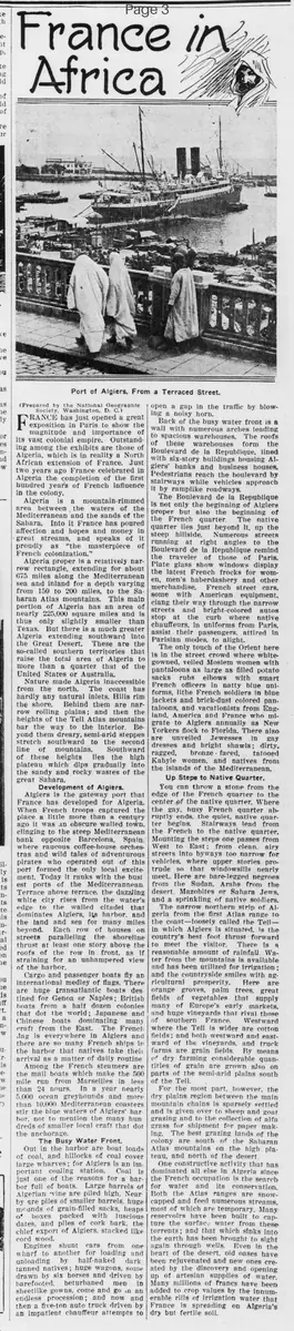
Port of Algiers, From a Terraced Street.
(Prepared by the National Geographic Society, Washington, D. C.)
France has just opened a great exposition in Paris to show the magnitude and importance of its vast colonial empire. Outstanding among the exhibits are those of Algeria, which is in reality a North African extension of France. Just two years ago France celebrated in Algeria the completion of the first hundred years of French influence in the colony.
Algeria is a mountain-rimmed area between the waters of the Mediterranean and the sands of the Sahara. Into it France has poured affection and hopes and money in great streams, and speaks of it proudly as "the masterpiece of French colonization."
Algeria proper is a relatively narrow rectangle, extending for about 675 miles along the Mediterranean sea and inland for a depth varying from 150 to 200 miles, to the Saharan Atlas mountains. This main portion of Algeria has an area of nearly 225,000 square miles and is thus only slightly smaller than Texas. But there is a much greater Algeria extending southward into the Great Desert. These are the so-called southern territories that raise the total area of Algeria to more than a quarter that of the United States or Australia.
Nature made Algeria inaccessible from the north. The coast has hardly any natural inlets. Hills rim the shore. Behind them are narrow rolling plains; and then the heights of the Tell Atlas mountains bar the way to the interior. Beyond them dreary, semi-arid steppes stretch southward to the second line of mountains. Southward of these heights lies the high plateau which dips gradually into the sandy and rocky wastes of the great Sahara.
Development of Algiers.
Algiers is the gateway port that France has developed for Algeria. When French troops captured the place a little more than a century ago it was an obscure walled town, clinging to the steep Mediterranean bank opposite Barcelona, Spain, where raucous coffee-house orchestras and wild tales of adventurous pirates who operated out of this port formed the only local excitement. Today it ranks with the busiest ports of the Mediterranean.
Terrace above terrace, the dazzling white city rises from the water's edge to the walled citadel that dominates Algiers, its harbor, and the land and sea for many miles beyond. Each row of houses on streets paralleling the shoreline thrust at least one story above the roofs of the row in front, as if straining for an unhampered view of the harbor.
Cargo and passenger boats fly an international medley of flags. There are huge transatlantic boats destined for Genoa or Naples; British boats from a half dozen colonies that dot the world; Japanese and Chinese boats dominating many craft from the East. The French flag is everywhere in Algiers and there are so many French ships in the harbor that natives take their arrival as a matter of daily routine. Among the French steamers are the mail boats which make the 500 mile run from Marseilles in less than 24 hours.
In a year nearly 5,000 ocean greyhounds and more than 10,000 Mediterranean coasters stir the blue waters of Algiers' harbor, not to mention the many hundreds of smaller local craft that dot the anchorage.
The Busy Water Front.
Out in the harbor are boat loads of coal, and hillocks of coal cover large wharves; for Algiers is an important coaling station. Coal is just one of the reasons for a harbor full of boats. Large barrels of Algerian wine are piled high. Nearby are piles of smaller barrels, huge mounds of grain-filled sacks, heaps of boxes packed with luscious dates, and piles of cork bark, the chief export of Algiers, stacked like cord wood.
Engines shunt cars from one wharf to another for loading and unloading by half-naked dark tanned natives; huge wagons, some drawn by six horses and driven by barefooted, beturbaned men in sheetlike gowns, come and go in an endless procession; and now and then a five-ton auto truck driven by an impatient chauffeur attempts to open a gap in the traffic by blowing a noisy horn.
Back of the busy water front is a wall with numerous arches leading to spacious warehouses. The roofs of these warehouses form the Boulevard de la Republique, lined with six-story buildings housing Algiers' banks and business houses. Pedestrians reach the boulevard by stairways while vehicles approach it by ramplike roadways.
The Boulevard de la Republique is not only the beginning of Algiers proper but also the beginning of the French quarter. The native quarter lies just beyond it, up the steep hillside. Numerous streets running at right angles to the Boulevard de la Republique remind the traveler of those of Paris. Plate glass show windows display the latest French frocks for women, men's haberdashery and other merchandise.
French street cars, some with American equipment, clang their way through the narrow streets and bright-colored autos stop at the curb where native chauffeurs, in uniforms from Paris, assist their passengers, attired in Parisian modes, to alight.
The only touch of the Orient here is in the street crowd where white-gowned, veiled Moslem women with pantaloons as large as filled potato sacks rubs elbows with smart French officers in natty blue uniforms, lithe French soldiers in blue jackets and brick-dust colored pantaloons, and vacationists from England, America and France who migrate to Algiers annually as New Yorkers flock to Florida. There also are unveiled Jewesses in gay dresses and bright shawls; dirty, ragged, bronze-faced, tattooed Kabyle women, and natives from the islands of the Mediterranean.
Up Steps to Native Quarter.
You can throw a stone from the edge of the French quarter to the center of the native quarter. Where the gay, busy French quarter abruptly ends, the quiet, native quarter begins. Stairways lead from the French to the native quarter. Mounting the steps one passes from West to East; from clean, airy streets into byways too narrow for vehicles, where upper stories protrude so that windowsills nearly meet. Here are bare-legged negroes from the Sudan, Arabs from the desert, Mazabites or Sahara Jews, and a sprinkling of native soldiers.
The narrow northern strip of Algeria from the first Atlas range to the coast—loosely called the Tell—in which Algiers is situated, is the country's best foot thrust forward to meet the visitor. There is a reasonable amount of rainfall. Water from the mountains is available and has been utilized for irrigation; and the countryside smiles with agricultural prosperity.
Here are orange groves, palm trees, great fields of vegetables that supply many of Europe's early markets, and huge vineyards that rival those of southern France. Westward where the Tell is wider are cotton fields; and both westward and eastward of the vineyards, and truck farms are grain fields.
By means of dry farming considerable quantities of grain are grown also on parts of the semi-arid plains south of the Tell.
For the most part, however, the dry plains region between the main mountain chains is sparsely settled and is given over to sheep and goat grazing and to the collection of alfa grass for shipment for paper making.
The best grazing lands of the colony are south of the Saharan Atlas mountains on the high plateau, and north of the desert.
One constructive activity that has dominated all else in Algeria since the French occupation is the search for water and its conservation. Both the Atlas ranges are snow-capped and feed numerous streams, most of which are temporary. Many reservoirs have been built to capture the surface water from these torrents; and that which sinks into the earth has been brought to sight again through wells.
Even in the heart of the desert, old oases have been rejuvenated and new ones created by the discovery and opening up of artesian supplies of water. Many millions of francs have been added to crop values by the innumerable rills of irrigation water that France is spreading on Algeria's dry but fertile soil.
What sub-type of article is it?
What keywords are associated?
Where did it happen?
Foreign News Details
Primary Location
Algeria
Outcome
french development has transformed algiers into a major port, enhanced agricultural prosperity through irrigation, and expanded the colony's area and economy.
Event Details
France showcases its colonial empire at a Paris exposition, emphasizing Algeria as a North African extension. Algeria spans 225,000 square miles along the Mediterranean, with southern territories extending into the Sahara. French influence, celebrated for 100 years two years ago, has developed Algiers from an obscure pirate port into a bustling Mediterranean hub with international shipping, exports like wine, dates, and cork, and modern infrastructure. The Tell region supports agriculture with irrigation from mountain streams and reservoirs, producing oranges, vegetables, vineyards, and grains for European markets.