Thank you for visiting SNEWPapers!
Sign up free
Story
June 12, 1897
The National Reflector
Wichita, Sedgwick County, Kansas
What is this article about?
The Mississippi River's irregular flooding, silt deposition, and channel shifts are detailed, along with its role in forming fertile lands and government interventions like levees since 1717 and jetties in 1875 to control floods.
Clipping
OCR Quality
98%
Excellent
Full Text
OUR MIGHTY RIVER.
ITS MAD CAREER HAS MADE MANY CHANGES.
The Mississippi Easily the Most Unruly Stream in the World—Efforts of the Government to Keep It Within Its Bounds.
The Mississippi is probably the most remarkable river in the world. The Nile, which it resembles more nearly than any other stream, is noted for the regularity with which it overflows its banks and recedes again to its former course.
This yearly action of the Nile in flooding the adjacent country and leaving it covered, when it withdrew, with a surface of rich, fertile mud, made a deep impression upon the ancient Egyptians and they worshiped the river as a great god. The Mississippi acts in the same way, with the exception that it is as irregular and uncertain as the Nile is regular and certain. It is also, in conjunction with the Missouri, the longest stream in the world, having a total length of 4,200 miles.
While the Nile has been rolling along for ages in the same channel, the Mississippi has been roaming all over its valley, twisting hither and thither, building up banks and then cutting through them and suddenly abandoning the old channel for a new one. It is doing the same thing today, and for the last thirty years the government and its ablest engineers have been studying the difficult problem of how to make the Mississippi river stay where it is and keep within its banks.
The cause of the trouble lies in the large amount of silt, a fine earthy sediment, or slime, which the Mississippi is constantly carrying down and emptying into the sea. The vast length of the Mississippi and its tributaries, measuring 9,000 miles of navigable waters and draining an area of 1,244,000 square miles, must account in a large part for the great quantity of this matter, but even when these facts are considered the estimate must still appear enormous. It is stated by experts who have made long and careful observations that the matter thus carried down by the Mississippi in a single year amounts to a solid mass one mile square and 163 feet deep. This sediment is being constantly deposited along the shores and upon the bars and islands that abound in this remarkable stream. Most of it, however, is carried down to the gulf, where it is added to that already there, forming the delta. This process has been going on for such a long time that the delta, which at some former age was located in the vincinity of the Red river, has been moved into the Gulf of Mexico a distance of 300 miles or more. All the country on both sides of the river for this 300 miles has been built up in this way. The land upon which the city of New Orleans is situated is part of this territory which the river has made.
Along the lower course of the Mississippi the natural banks of the river are in many cases in the nature of levees, having been added to by the stream until they are higher than the surrounding country. The strange phenomenon of having to walk "up" to the shore of the river, instead of "down," is frequently met with in this part of the country.
But the very nature of the soil with which the bars, islands and banks of the Mississippi have been built make them of very uncertain length of life. Being composed in the first place of so much water and being deposited in or near the river, it is very soluble. The water enters into it easily, undermines and eats it away until suddenly the bank, island or bar gives way and in a few moments the course of the river undergoes a great change.
It is this uncertain habit the river has of suddenly shifting its course or changing its appearance that adds an element of danger to life in its vicinity and makes it so difficult to navigate. Sometimes a steamboat in coming up the stream will pass directly over the spot where stood an island when it passed down a few days before. Or perhaps it will find a new island or bar where the water was formerly clear, and have to sail over what was before a farm or plantation, and leave the side. This has frequently led to disputes and law suits between farmers whose lands had been seized by the river and those on the other side who suddenly found large tracts of rich, fertile soil added to their domains.
To this habit the river has of depositing sediment along its banks must also be ascribed the numerous twistings and turnings in the channel which follow one another so closely. A small bar or other obstruction starting out from the shore catches the silt as it comes down and soon builds up a curving bank that turns the course of the stream. Still the water keeps adding more matter to it and extending it further and further around until the river is flowing in an opposite direction to that it ought to follow. Sometimes it almost describes a complete circle before it is turned again in the right direction. The whole course of the Mississippi, from the mouth of the Missouri down, is a series of large, graceful bends, one after another. The distance from St. Louis to the sea as the river makes the journey is 1,300 miles, but in a straight line it is not quite 700 miles. This, because of the obstructions which the river is constantly carrying down and placing in its own path, it is obliged to travel nearly twice as far as is necessary between these two points.
Look on any large map of the Mississippi valley south of Mason and Dixon's line, you will see on either side of the river, and quite distinct from it, a large number of small, circular lakes. Some of these have merely a slight bend, while others have the shape of horseshoes. These crescent-shaped lakes indicate the fact that at sometime in the past they formed part of the course of the Mississippi. But finding that it was going in the wrong direction, the river must have broken a new path through its soft banks and left the curve to one side.
Besides these "cut-offs," as they are called, a great number of peculiar mounds, such as form the banks of the stream, are scattered through the territory adjacent to the river, showing that the Mississippi must have passed over a good part of the valley at different times in the past while on its way to the sea.
This fact explains the remarkable fertility of the land near the lower Mississippi. A great part of it has been built entirely of this rich river deposit, as the delta is being built at present, while the rest has been thickly coated with it during the various times that it formed a part of the river bed. This part of the valley is acknowledged to be the most productive land in the world. It is composed largely of mineral substances, but contains also considerable vegetable matter, making it the richest fertilizer known. It grows wheat, corn, cotton, sugar, rice and all manner of vegetables in wonderful profusion and in a very short time. One acre produces seventy bushels of wheat in a single crop, whereas thirty bushels is considered good in other places.
No one can find any fault with the conduct of the Mississippi in former times, for it has made the country through which it flows worthy of its title, "The Garden of the World." But now things are different. The land has all been occupied, the people are engaged in tilling the soil and they want the river to leave them alone. They would like it to forego the wandering habits of its youth and settle down into one certain course. But this the river is loath to do. Many schemes have been suggested for compelling it to stay where it is, but the levee and jetty system seems to be the only feasible one.
The first levee was built as long ago as 1717. In that year De la Tour, a French engineer, constructed one about a mile long for the protection of the infant city of New Orleans. From that small beginning they have been gradually added to until now they extend up the east bank almost to Memphis, and up the west bank to a point opposite the mouth of the Ohio. But although they are being strengthened each year, they are still far from perfect. They have to stand an enormous pressure, especially in flood time, and as the only earth available for their construction is the soft soil that is found in the vicinity of the river, they are easily acted upon by the water.
The clearing away of obstructions in the rivers all over the northern part of the country and the destruction of the forests are supposed to contribute largely to the severity of the floods of late years. The spring rains formerly took months to reach the main river are now precipitate most at once upon the lower Mississippi, causing great loss of life and property. If all this extra water could be carried off as fast as it comes down the rivers, there would be no danger of destruction owing to the tortuous nature of the channel and the obstruction of the delta, this is impossible.
In 1875 congress authorized Eads to begin the construction of jetties in the branches of the delta. When the river reaches the delta it divides and flows into the sea through five different outlets, called passes. In these passes Capt. Eads built long walls of masonry, confining the stream to a narrow channel. This had the effect of quickening the current, scouring out the bottom of the channel, deepening it and carrying off all obstructions. Extensive dredging operations were also begun for clearing the passes and allowing the water to reach the gulf more quickly.
These are the plans upon which the work of confining the Mississippi to its present channel is being carried on. But it will probably be some time before the levees and jetties are of sufficient strength and extent to remove all danger of floods. Whether the current can be quickened enough to carry all the sediment and thus remove the possibility of shifting bars and deepening the channel is a doubtful question.
ITS MAD CAREER HAS MADE MANY CHANGES.
The Mississippi Easily the Most Unruly Stream in the World—Efforts of the Government to Keep It Within Its Bounds.
The Mississippi is probably the most remarkable river in the world. The Nile, which it resembles more nearly than any other stream, is noted for the regularity with which it overflows its banks and recedes again to its former course.
This yearly action of the Nile in flooding the adjacent country and leaving it covered, when it withdrew, with a surface of rich, fertile mud, made a deep impression upon the ancient Egyptians and they worshiped the river as a great god. The Mississippi acts in the same way, with the exception that it is as irregular and uncertain as the Nile is regular and certain. It is also, in conjunction with the Missouri, the longest stream in the world, having a total length of 4,200 miles.
While the Nile has been rolling along for ages in the same channel, the Mississippi has been roaming all over its valley, twisting hither and thither, building up banks and then cutting through them and suddenly abandoning the old channel for a new one. It is doing the same thing today, and for the last thirty years the government and its ablest engineers have been studying the difficult problem of how to make the Mississippi river stay where it is and keep within its banks.
The cause of the trouble lies in the large amount of silt, a fine earthy sediment, or slime, which the Mississippi is constantly carrying down and emptying into the sea. The vast length of the Mississippi and its tributaries, measuring 9,000 miles of navigable waters and draining an area of 1,244,000 square miles, must account in a large part for the great quantity of this matter, but even when these facts are considered the estimate must still appear enormous. It is stated by experts who have made long and careful observations that the matter thus carried down by the Mississippi in a single year amounts to a solid mass one mile square and 163 feet deep. This sediment is being constantly deposited along the shores and upon the bars and islands that abound in this remarkable stream. Most of it, however, is carried down to the gulf, where it is added to that already there, forming the delta. This process has been going on for such a long time that the delta, which at some former age was located in the vincinity of the Red river, has been moved into the Gulf of Mexico a distance of 300 miles or more. All the country on both sides of the river for this 300 miles has been built up in this way. The land upon which the city of New Orleans is situated is part of this territory which the river has made.
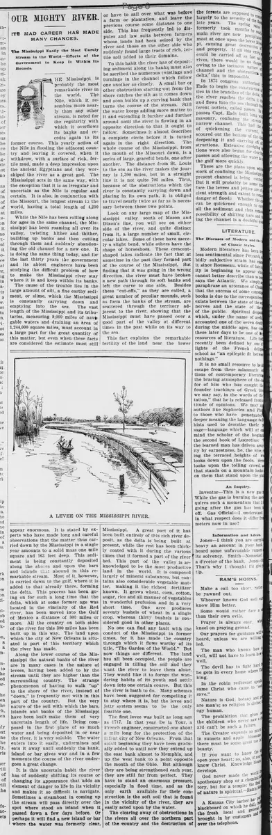
Along the lower course of the Mississippi the natural banks of the river are in many cases in the nature of levees, having been added to by the stream until they are higher than the surrounding country. The strange phenomenon of having to walk "up" to the shore of the river, instead of "down," is frequently met with in this part of the country.
But the very nature of the soil with which the bars, islands and banks of the Mississippi have been built make them of very uncertain length of life. Being composed in the first place of so much water and being deposited in or near the river, it is very soluble. The water enters into it easily, undermines and eats it away until suddenly the bank, island or bar gives way and in a few moments the course of the river undergoes a great change.
It is this uncertain habit the river has of suddenly shifting its course or changing its appearance that adds an element of danger to life in its vicinity and makes it so difficult to navigate. Sometimes a steamboat in coming up the stream will pass directly over the spot where stood an island when it passed down a few days before. Or perhaps it will find a new island or bar where the water was formerly clear, and have to sail over what was before a farm or plantation, and leave the side. This has frequently led to disputes and law suits between farmers whose lands had been seized by the river and those on the other side who suddenly found large tracts of rich, fertile soil added to their domains.
To this habit the river has of depositing sediment along its banks must also be ascribed the numerous twistings and turnings in the channel which follow one another so closely. A small bar or other obstruction starting out from the shore catches the silt as it comes down and soon builds up a curving bank that turns the course of the stream. Still the water keeps adding more matter to it and extending it further and further around until the river is flowing in an opposite direction to that it ought to follow. Sometimes it almost describes a complete circle before it is turned again in the right direction. The whole course of the Mississippi, from the mouth of the Missouri down, is a series of large, graceful bends, one after another. The distance from St. Louis to the sea as the river makes the journey is 1,300 miles, but in a straight line it is not quite 700 miles. This, because of the obstructions which the river is constantly carrying down and placing in its own path, it is obliged to travel nearly twice as far as is necessary between these two points.
Look on any large map of the Mississippi valley south of Mason and Dixon's line, you will see on either side of the river, and quite distinct from it, a large number of small, circular lakes. Some of these have merely a slight bend, while others have the shape of horseshoes. These crescent-shaped lakes indicate the fact that at sometime in the past they formed part of the course of the Mississippi. But finding that it was going in the wrong direction, the river must have broken a new path through its soft banks and left the curve to one side.
Besides these "cut-offs," as they are called, a great number of peculiar mounds, such as form the banks of the stream, are scattered through the territory adjacent to the river, showing that the Mississippi must have passed over a good part of the valley at different times in the past while on its way to the sea.
This fact explains the remarkable fertility of the land near the lower Mississippi. A great part of it has been built entirely of this rich river deposit, as the delta is being built at present, while the rest has been thickly coated with it during the various times that it formed a part of the river bed. This part of the valley is acknowledged to be the most productive land in the world. It is composed largely of mineral substances, but contains also considerable vegetable matter, making it the richest fertilizer known. It grows wheat, corn, cotton, sugar, rice and all manner of vegetables in wonderful profusion and in a very short time. One acre produces seventy bushels of wheat in a single crop, whereas thirty bushels is considered good in other places.
No one can find any fault with the conduct of the Mississippi in former times, for it has made the country through which it flows worthy of its title, "The Garden of the World." But now things are different. The land has all been occupied, the people are engaged in tilling the soil and they want the river to leave them alone. They would like it to forego the wandering habits of its youth and settle down into one certain course. But this the river is loath to do. Many schemes have been suggested for compelling it to stay where it is, but the levee and jetty system seems to be the only feasible one.
The first levee was built as long ago as 1717. In that year De la Tour, a French engineer, constructed one about a mile long for the protection of the infant city of New Orleans. From that small beginning they have been gradually added to until now they extend up the east bank almost to Memphis, and up the west bank to a point opposite the mouth of the Ohio. But although they are being strengthened each year, they are still far from perfect. They have to stand an enormous pressure, especially in flood time, and as the only earth available for their construction is the soft soil that is found in the vicinity of the river, they are easily acted upon by the water.
The clearing away of obstructions in the rivers all over the northern part of the country and the destruction of the forests are supposed to contribute largely to the severity of the floods of late years. The spring rains formerly took months to reach the main river are now precipitate most at once upon the lower Mississippi, causing great loss of life and property. If all this extra water could be carried off as fast as it comes down the rivers, there would be no danger of destruction owing to the tortuous nature of the channel and the obstruction of the delta, this is impossible.
In 1875 congress authorized Eads to begin the construction of jetties in the branches of the delta. When the river reaches the delta it divides and flows into the sea through five different outlets, called passes. In these passes Capt. Eads built long walls of masonry, confining the stream to a narrow channel. This had the effect of quickening the current, scouring out the bottom of the channel, deepening it and carrying off all obstructions. Extensive dredging operations were also begun for clearing the passes and allowing the water to reach the gulf more quickly.
These are the plans upon which the work of confining the Mississippi to its present channel is being carried on. But it will probably be some time before the levees and jetties are of sufficient strength and extent to remove all danger of floods. Whether the current can be quickened enough to carry all the sediment and thus remove the possibility of shifting bars and deepening the channel is a doubtful question.
What sub-type of article is it?
Curiosity
Historical Event
What themes does it cover?
Nature
Catastrophe
What keywords are associated?
Mississippi River
Silt Deposition
River Shifts
Floods
Levees
Jetties
Delta Formation
What entities or persons were involved?
De La Tour
Capt. Eads
Where did it happen?
Mississippi River Valley, New Orleans, Gulf Of Mexico
Story Details
Key Persons
De La Tour
Capt. Eads
Location
Mississippi River Valley, New Orleans, Gulf Of Mexico
Event Date
1717; 1875
Story Details
The Mississippi River, the longest and most unruly stream, carries vast silt that builds deltas, shifts channels, and causes floods. Government efforts since 1717 include levees and 1875 jetties to confine it and prevent disasters.