Thank you for visiting SNEWPapers!
Sign up free
The Enquirer
Richmond, Henrico County, Virginia
What is this article about?
Vermont Governor reports to legislature that astronomical observations by Dr. Williams show the northern boundary with Lower Canada is south of the 45th parallel, potentially adding 18 townships to the state. Recommends application to national government. Assembly notes possible effects on New York.
Clipping
OCR Quality
Full Text
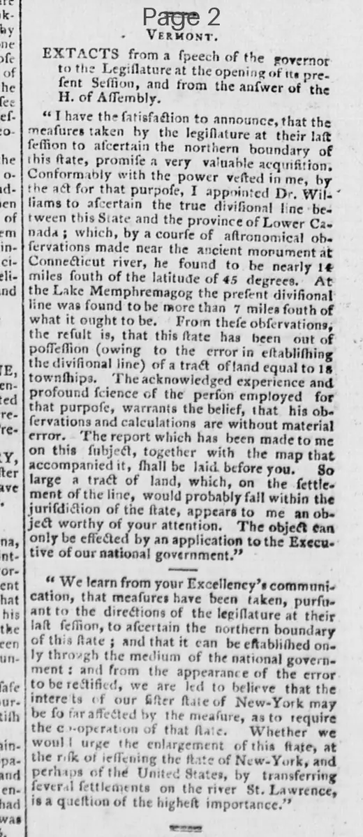
EXTRACTS from a speech of the governor to the Legislature at the opening of its present Session, and from the answer of the H. of Assembly.
"I have the satisfaction to announce, that the measures taken by the legislature at their last session to ascertain the northern boundary of this state, promise a very valuable acquisition. Conformably with the power vested in me, by the act for that purpose, I appointed Dr. Williams to ascertain the true divisional line between this State and the province of Lower Canada; which, by a course of astronomical observations made near the ancient monument at Connecticut river, he found to be nearly 1 1/2 miles south of the latitude of 45 degrees. At the Lake Memphremagog the present divisional line was found to be more than 7 miles south of what it ought to be. From these observations, the result is, that this state has been out of possession (owing to the error in establishing the divisional line) of a tract of land equal to 18 townships. The acknowledged experience and profound science of the person employed for that purpose, warrants the belief, that his observations and calculations are without material error. The report which has been made to me on this subject, together with the map that accompanied it, shall be laid before you. So large a tract of land, which, on the settlement of the line, would probably fall within the jurisdiction of the state, appears to me an object worthy of your attention. The object can only be effected by an application to the Executive of our national government."
"We learn from your Excellency's communication, that measures have been taken, pursuant to the directions of the legislature at their last session, to ascertain the northern boundary of this state; and that it can be established only through the medium of the national government: and from the appearance of the error to be rectified, we are led to believe that the interests of our sister state of New-York may be so far affected by the measure, as to require the co-operation of that State. Whether we would urge the enlargement of this state, at the risk of lessening the state of New-York, and perhaps of the United States, by transferring several settlements on the river St. Lawrence, is a question of the highest importance."
What sub-type of article is it?
What keywords are associated?
What entities or persons were involved?
Where did it happen?
Domestic News Details
Primary Location
Vermont
Event Date
Present Session
Key Persons
Outcome
potential acquisition of tract equal to 18 townships; requires application to national government and possible cooperation with new-york
Event Details
Governor announces measures to ascertain northern boundary with Lower Canada via Dr. Williams' astronomical observations, finding the line south of 45 degrees latitude, resulting in loss of 18 townships; report and map to be presented; suggests attention and national application. Assembly acknowledges and notes impact on New-York and St. Lawrence settlements.