Thank you for visiting SNEWPapers!
Sign up free
Fowle's New Hampshire Gazette And General Advertiser
Portsmouth, Rockingham County, New Hampshire
What is this article about?
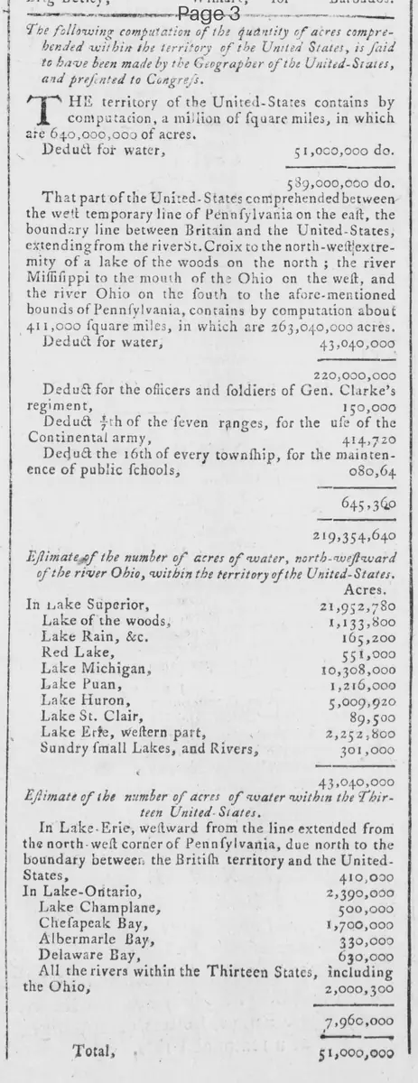
Computation by the Geographer of the United States, presented to Congress, estimates total US territory at 640 million acres, deducting 51 million for water, leaving 589 million. Northwestern territory breakdown: 263 million acres total, deducting for water, military, and schools, netting 219 million. Detailed water acreage estimates for lakes and bays provided.
Clipping
OCR Quality
Full Text
The territory of the United-States contains by computation, a million of square miles, in which are 640,000,000 of acres.
Deduct for water,
51,000,000 do.
589,000,000 do.
That part of the United-States comprehended between the west temporary line of Pennsylvania on the east, the boundary line between Britain and the United-States, extending from the river St. Croix to the north-west extremity of a lake of the woods on the north; the river Mississippi to the mouth of the Ohio on the west, and the river Ohio on the south to the afore-mentioned bounds of Pennsylvania, contains by computation about 411,000 square miles, in which are 263,040,000 acres.
Deduct for water,
43,040,000
220,000,000
Deduct for the officers and soldiers of Gen. Clarke's regiment,
150,000
Deduct 1/3 of the even ranges, for the use of the Continental army,
414,720
Deduct the 1/6 of every township, for the maintenance of public schools,
80,640
645,360
219,354,640
Estimate of the number of acres of water, north-westward of the river Ohio, Within the territory of the United-States.
Acres.
In Lake Superior,
21,952,780
Lake of the woods,
1,133,800
Lake Rain, &c.
165,200
Red Lake,
551,000
Lake Michigan,
10,308,000
Lake Puan,
1,216,000
Lake Huron,
5,009,920
Lake St. Clair,
89,500
Lake Erie, western part,
2,252,800
Sundry small Lakes, and Rivers,
301,000
43,040,000
Estimate of the number of acres of water within the Thirteen United-States.
In Lake Erie, westward from the line extended from the north-west corner of Pennsylvania, due north to the boundary between the British territory and the United-States,
410,000
In Lake Ontario,
2,390,000
Lake Champlain,
500,000
Chesapeak Bay,
1,700,000
Albemarle Bay,
330,000
Delaware Bay,
630,000
All the rivers within the Thirteen States, including the Ohio;
2,000,000
7,960,000
Total;
51,000,000
What sub-type of article is it?
What keywords are associated?
What entities or persons were involved?
Where did it happen?
Domestic News Details
Primary Location
United States
Key Persons
Outcome
total territory: 640,000,000 acres (589,000,000 land after water deduction). northwestern territory: 219,354,640 acres after deductions for water, military, and schools. water estimates: 43,040,000 acres northwest of ohio; 51,000,000 total including thirteen states.
Event Details
Computation of acres in US territory presented to Congress by the Geographer, including total square miles, water deductions, northwestern territory boundaries and deductions for Gen. Clarke's regiment, Continental army, and public schools, plus detailed estimates of water acres in various lakes, bays, and rivers.